Laura heads towards gulf coast, Katy area rains expected between 2 and 4 inches
Hurricane Laura is heading toward the gulf coast and is expected to impact areas from San Luis Pass on the south end of Galveston Island north and east to the mouth of the Mississippi River according …
This item is available in full to subscribers.
Attention subscribers
To continue reading, you will need to either log in to your subscriber account, below, or purchase a new subscription.
Please log in to continue |
Laura heads towards gulf coast, Katy area rains expected between 2 and 4 inches
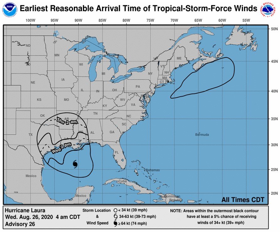
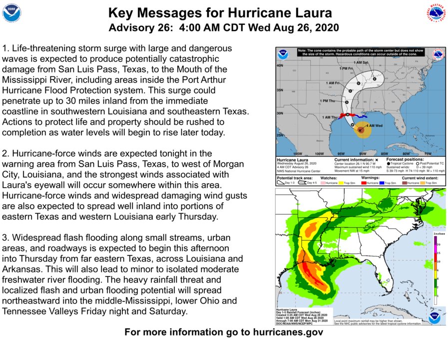
Hurricane Laura is heading toward the gulf coast and is expected to impact areas from San Luis Pass on the south end of Galveston Island north and east to the mouth of the Mississippi River according to the National Weather Service. Landfall is expected to occur this afternoon with the storm arriving in full at about 6 p.m.
A tropical storm warning is currently in effect from now until further notice, an announcement on the NWS website says.
Jeff Lindner, meteorologist for the Harris County Flood Control District said during a briefing at about 6 a.m. Wednesday morning that Laura is now a category 3 hurricane and is continuing to intensify. Lindner said he expects the storm to be a Category 4 hurricane by the time it makes landfall.
By Thursday at 2 a.m. the leading edge of the storm is expected to have moved inland toward Oklahoma, Arkansas and Tennessee, according to National Weather Service maps.
Winds are expected to be the primary concern as Laura moves inland Texas Governor Greg Abbott said earlier this week.
Winds will be faster east of I-45 but west of that interstate should be slower. Winds in the Katy area may reach speeds between 25 and 35 mph Lindner said, though with the unpredictability of the storm that may be a bit higher. Lindner did say that meteorologists do feel the path of the storm is expected to remain true to models now in contrast to earlier forecasts when the storm was first forming and Tropical Storm Marco had a chance of affecting Laura’s path.
Residents are advised to secure trash cans, trampolines and other outdoor equipment that may be blown around by heavy winds and cause damage.
The Harris County Flood Control District is currently expecting 2-4 inches of rainfall across Harris County. Storm surge flooding of 2-4 feet above normal dry ground is expected near some tributaries on the eastern side of Harris County as ocean water is pushed in by the storm; however, those sorts of storm surges should not affect the Katy area.
Evacuation recommendations and orders for portions of the gulf coast have been issued, but none are in effect for the Katy area at this time. Abbott has issued disaster declarations for Fort Bend, Harris and Waller counties as of Tuesday afternoon.
The City of Katy has issued a press release recommending residents prepare for the storm by securing their homes and outdoor items that may be blown around and become dangerous debris. The city also offers the KT Alert system that residents can sign up for on the city’s website.
Brookshire residents are advised to follow the Brookshire Police Department’s Facebook Page for updates and alerts.
Readers should make sure they have everything prepared in case the storm becomes more intense than what meteorologists are currently predicting. Outdoor pets and livestock should be secured in order to ensure they are not injured in the storm.
President Donald Trump has issued disaster declarations for Texas and Louisiana, as well as states that will be impacted as Laura moves inland. This allows the Federal Emergency Management Agency to begin work to aid those affected by the storm.
Katy Times will have additional updates throughout the day as they become available.
Keywords
Hurricane Laura, Jeff Lindner


